

2021Summer
Larger-than-average Gulf of Mexico 'Dead Zone' Measured
By Jennie Lyons and Sierra Sarkis
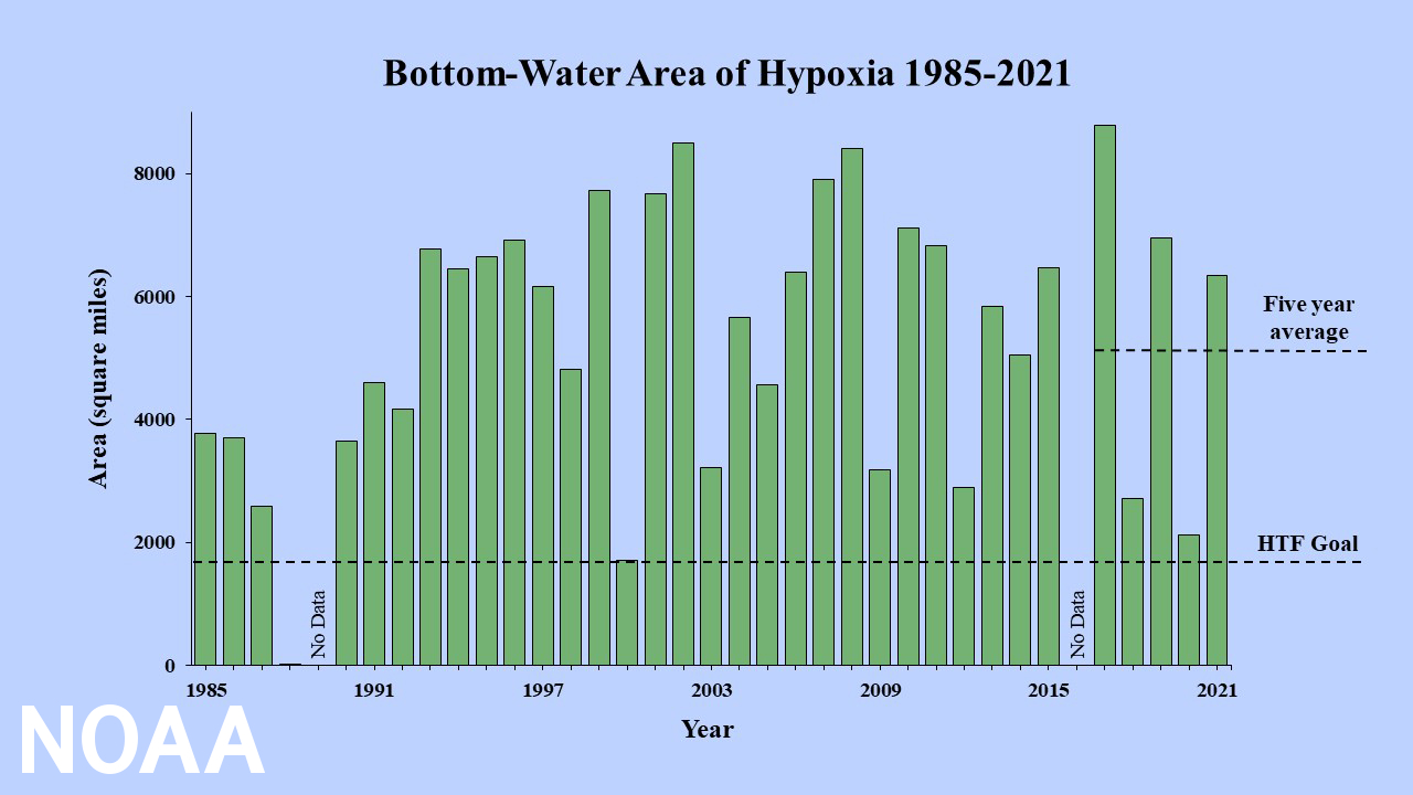
Long-term measured size of the hypoxic zone (green bars) measured during the ship surveys since 1985, including the target goal established by the Mississippi River/Gulf of Mexico Watershed Nutrient Task Force and the 5-year average measured size (black dashed lines). Photo by LUMCON/NOAA
The average hypoxic zone over the past five years is 5,380 square miles, which is 2.8 times larger than the 2035 target set by the Hypoxia Task Force. Since records began in 1985, the largest hypoxic zone measured was 8,776 square miles in 2017.
Scientists at Louisiana State University and the Louisiana Universities Marine Consortium led the annual dead zone survey during a research cruise from July 25 to August 1 aboard the R/V Pelican.
"The distribution of the low dissolved oxygen was unusual this summer," said Nancy Rabalais, Ph.D., professor at Louisiana State University and LUMCON who is the principal investigator.
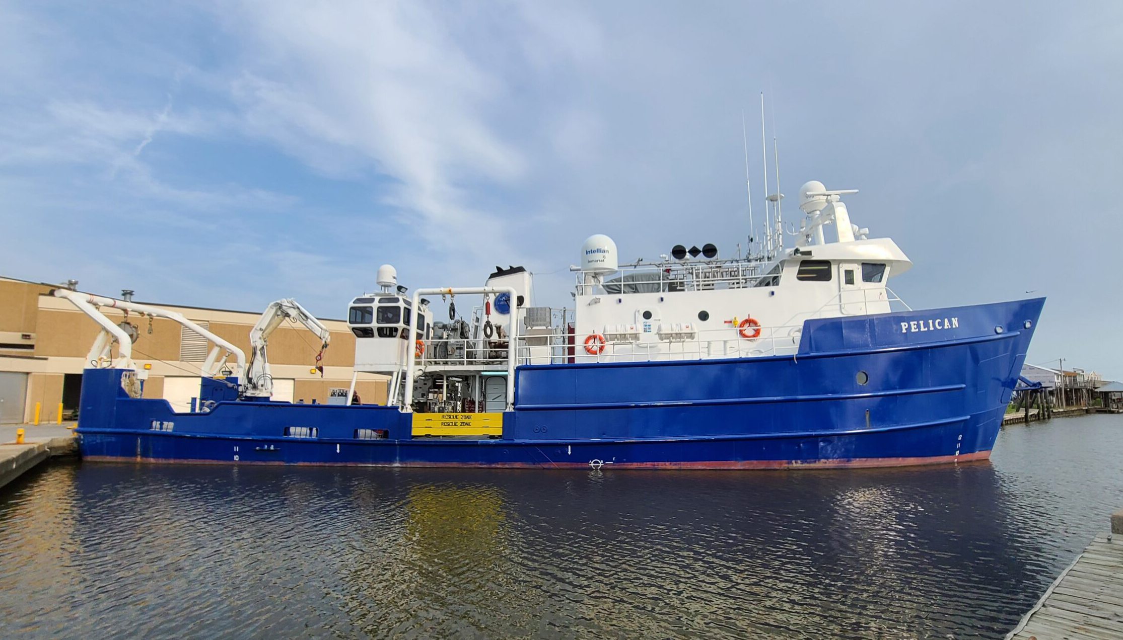
The R/V Pelican at dock before heading out to sample the Gulf of Mexico hypoxic zone. The annual survey cruise has been performed since 1985, creating an important long-term data set for scientists. (LUMCON/LSU)
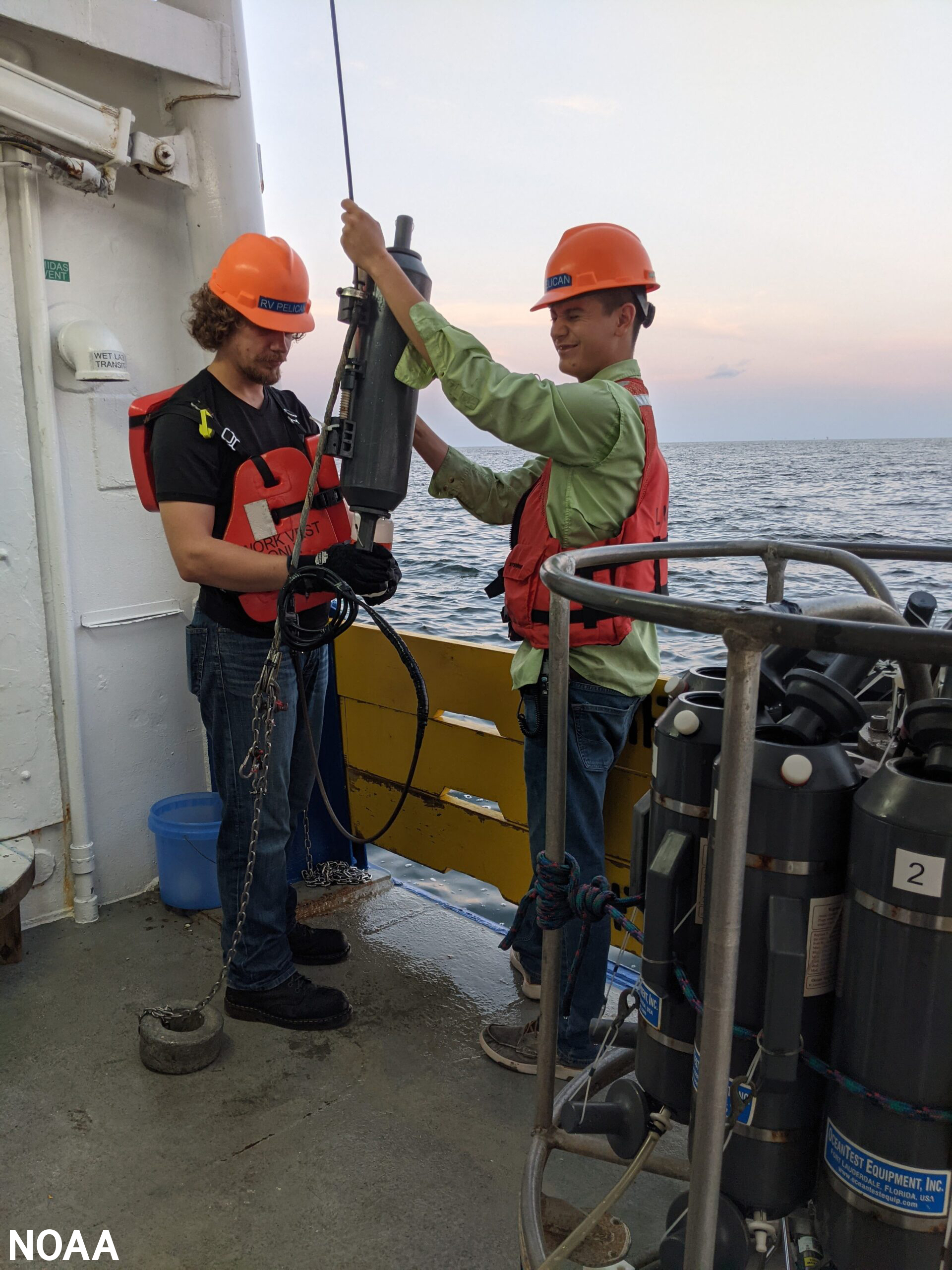
Scientists prepare to collect near-bottom water aboard the R/V Pelican to verify oxygen measurements used to determine the size of the Gulf of Mexico hypoxic zone. Photo by LUMCON/LSU
The role of chief scientist was shared by Rabalais, Cassandra Glaspie, Ph.D., of LSU, and Gina Woods, LUMCON research associate. The 2021 shelf wide cruise had a full complement of scientists, which was curtailed in 2020 due to COVID restrictions.
In June, NOAA forecasted an average-sized hypoxic zone of 4,880 square miles, based primarily on the Mississippi River discharge and nutrient runoff data from the U.S. Geological Survey. With average- to below-average discharge and nutrient loading this spring, the models predicted an average hypoxic zone to form during the time of the cruise. The forecast models assume typical weather conditions and do not have capacity to factor in storms or other wind events, which can disrupt the hypoxia zone around the time of the cruise. While the model results underestimated the measured size of the zone this year, they were within the expected margin of uncertainty for the forecast and provide further evidence of the robustness of the models to relate nutrient inputs to observed hypoxia size in the summer.
The full report is available here.
- MSU-led Northern Gulf Institute Receives Up to $86 Million from NOAA for Gulf of Mexico Research
- Mississippi State University, ASSURE's Lead University and Kansas State University Partner to Lead First Responder UAS Competition
- CAVS is Partnering with ERDC to Lead a $7.8 million U.S. Department of Defense Project to Advance Military Engineering Capabilities
- CAVS Researcher Honored with Alumni Association Graduate Teaching Excellence Award
- CAVS Researcher Part of NREL $5.18 million Department of Energy Grant to Boost Solar Energy for Resilient Community Microgrids
- MSU's Center for Cyber Innovation, Keesler Air Force Base and MSGCCC Continue to Expand Cyber Efforts to Address Cyber Security Issues
- ASSURE's Research Partner, RFRL at Mississippi State, Works with ARM Aerial Facility Testing Instrument Configuration in Skies Above Mississippi
- DoD Awards Prestigious SMART Scholarship to GRI Researcher
- Cartwright Leads the Nation's Largest Geospatial Education and Outreach Project of its Kind to Help Protect and Manage Coastal and Marine Resources
- Griffiss Institute Announces Awardees in New Program That Addresses Urgent Need to Grow Cybersecurity Workforce
- Geosystems Research Institute and Center for Advanced Vehicular Systems' Researchers Honored as Newest Grisham Master Teachers, Giles Distinguished Professors
- ASSURE Research Partner, MSU Raspet Flight Research Lab, Makes History in Unmanned Aviation at State's Busiest Airport
- Northern Gulf Institute's Cebrian and Geosystems Research Institute's Turnage Recognized for Outstanding Research Accomplishments
- ASSURE, WiBiotic and University of Montana Collaborate to Upgrade UAS Battery Power, Recharging Technology to Use Drones to Help Fight Wildfires
- CAVS GRA Blends Musicianship with Software Engineering to Inspire Next Generation and Protect America's Military
- Mississippi Academy of Sciences Names GRI Researcher Inaugural Fellow
- CAVS Researchers, Stone and Du, Among 24 MSU Professors Who Complete Faculty Leadership Development Institute
- CAVS and GRI Researcher Receives NSF CAREER Award for Research to Advance Smart Sensing Systems
- NGI and NOAA Research Partner, Louisiana Universities Marine Consortium, Release 2021 Northern Gulf of Mexico Summer Hypoxic Zone Size Forecast
- CAVS Making Innovative Materials for Research
- IEEE Signal Processing Magazine Features CAVS Researchers' New Sensor Processing Course with State-of-the-Art Physics-based Autonomy Simulator
- MSU and the Mississippi Aquarium Partner, Launch First MSU-SEAS Program