
News at the HPC²
Making the Unpredictable Predictable in Hurricane Forecasts
August 2, 2022
Inside the eyewall of 2020 Hurricane Epsilon as seen by the Hurricane Hunters 53rd Weather Reconnaissance Squadron.
The new method they developed involves combining atmospheric data collected in a hurricane approximately 1 km above the ocean's surface (the Planetary Boundary Layer, PBL, also called the Hurricane Boundary Layer) with a special model (large-eddy simulations or LES) that can directly predict the behavior of wind turbulence or turbulent eddies. This combination assists a hurricane model to make predictions with reduced uncertainty because its calculations incorporate a more accurate reflection of the turbulent conditions as a tropical cyclone develops.
"We developed a modeling framework that integrates in-situ observations and LES to study the hurricane boundary layer," explained meteorologist Xiaomin Chen with Mississippi State University. "One important application of this framework is to assess the performance and uncertainties in various types of PBL parameterization schemes in hurricane conditions."
The in-situ observations that Chen referred to come from dropsonde, weather devices released during hurricane hunter flights into category 4 or 5 hurricanes from 1999–2010 that detect and record wind speed and direction, temperature and moisture as the device falls through the atmosphere. The LES simulations using the observed hurricane conditions provided reliable information on the mean size of turbulence eddies and the energy produced by turbulent winds (turbulence kinetic energy or TKE) to evaluate and improve different types of PBL schemes used in hurricane models.
Chen explained the role that PBL schemes play in hurricane forecasts, "The size of turbulence is sometimes less than 100 yards across, comparable to the length of a football field. While LES can predict turbulence with comparably small model grids, meteorologists do not use LES for hurricane forecasts due to the overwhelming computing resource it requires as a hurricane can span hundreds of miles. Instead, meteorologists use computer models with the distance of model grid points of a few miles from each other, meaning we cannot directly predict the turbulence processes in these models. PBL schemes are the technique that models use to mimic what is happening on these small scales."
The issue with current PBL schemes is that they are generally designed for non-hurricane conditions, including the PBL scheme (TKE-based moist eddy-diffusivity mass-flux or EDMF-TKE) used in the latest NOAA model, the Hurricane Analysis and Forecast System (HAFS). Chen and his colleagues aimed to improve how PBL schemes are represented in the HAFS.
"Using our framework, we improved the EDMF-TKE PBL scheme in the NOAA HAFS," said Chen. "The modified EDMF-TKE scheme ensures a match between surface-layer and PBL parameterizations and adopts the information of turbulence eddies from LES."
By providing a PBL scheme that incorporates turbulence data from LES, the researchers help the model adjust its representation of fundamental physical processes to better reflect actual conditions as Chen summarized, "Using the LES output, the modified EDMF-TKE PBL scheme enhances boundary layer inflow and shows promise to improve forecast skill in the rapid intensification of landfalling hurricanes."
This research was supported by the NOAA Office of Oceanic and Atmospheric Research award to the Northern Gulf Institute and by the National Center for Atmospheric Research, a National Research Council Research Associateship Award, the Office of Naval Research, and the National Science Foundation.
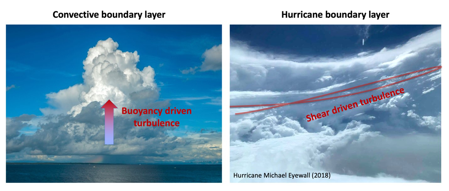
The structure of wind turbulence (visualized here with moist, cloudy air) is different under low- and high-wind conditions. On the left during low-wind conditions, moist air is driven upwards. On the right during high-wind conditions, moist air is driven sideways as well. The new modeling framework developed by Chen et al., allows hurricane forecasts to better reflect the high-wind conditions as a tropical cyclone develops. Figure by Xiaomin Chen. Left image by Sandro Puncet, with permission. Right image by Air Force Reserve 53rd Weather Reconnaissance Squadron.
By Nilde Maggie Dannreuther and Xiaomin Chen, Northern Gulf Institute, Mississippi State University.
The Northern Gulf Institute is a National Oceanic and Atmospheric Administration Cooperative Institute comprised of six academic institutions located across the US Gulf Coast states. The diverse strengths within NGI allow it to conduct research on the interconnections among Gulf of Mexico ecosystems (environments, habitats, resources, and people) and outreach for decision-making based on these interconnections.